T4K3.news
Hurricane Erin strengthens to Category 4
Erin intensified to Category 4 in the western Atlantic with 145 mph winds; forecast suggests possible size growth and risk to Bermuda and the U.S. East Coast. A separate disturbance near NC has 10 percent development chance.

Hurricane Erin rapidly intensified to a Category 4 hurricane with potential for further growth, posing risks to Bermuda and the U.S. East Coast.
Hurricane Erin Strengthens to Category 4 Threatening Bermuda and East Coast
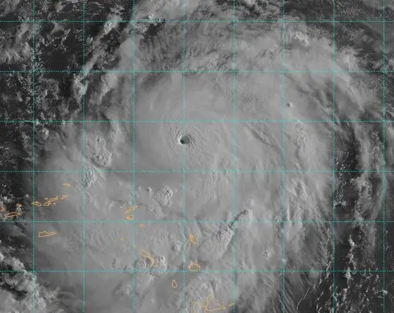
Hurricane Erin has strengthened to a Category 4 hurricane in the western Atlantic, with sustained winds of 145 mph and a minimum pressure near 935 mb as of 8:00 am AST on August 16. Forecasters say Erin could continue to rapidly strengthen in warm water, low wind shear, and a moist environment, with some models hinting at a possible approach to Category 5. The storm displays a clear eye and a well defined eyewall, signaling a powerful system that could grow in size while maintaining intensity. Erin is expected to pass between Bermuda and the East Coast, and models indicate the system may enlarge over the next several days, bringing large swells and a higher rip current threat to the US coastline. A separate disturbance off the North Carolina coast has about a 10 percent chance of development in the coming days. While Erin does not pose a direct US landfall threat, its evolution raises coastal and maritime risks.
Key Takeaways
"Erin is expected to continue to rapidly strengthen over the next 12 hours while it remains in favorable conditions of warm water, low wind shear, and in an environment of high moisture"
Forecast statement from the National Hurricane Center cited in the article
"Storm tracking is a moving target as Erin grows in size"
Editorial observation on forecast uncertainty
"Rapid intensification may outpace local warning timelines"
Insight on warning systems
"Prepare now because forecast changes can affect coastal communities"
Public readiness message
Erin highlights how rapidly storms can intensify and how size matters as much as wind speed. The forecast uncertainty about Erin future size complicates local preparedness, making it essential for officials to communicate clear guidance rather than relying on narrow center tracks. The event also underscores the need for robust coastal infrastructure planning and sustained public readiness to handle swells and rip currents even when direct landfall is not imminent.
Highlights
- Size matters more than winds in Erin's rapid rise
- Forecasts can change quickly as storms grow bigger
- Prepare now before the forecast moves closer to land
- The coast should stay cautious as Erin evolves
Coastal risk grows as Erin strengthens
Rapid intensification and potential growth in storm size raise public safety and infrastructure concerns for Bermuda and the U.S. East Coast; the evolving track creates uncertainty for local authorities and residents.
Preparedness remains the true measure of resilience as Erin evolves.
Enjoyed this? Let your friends know!
Related News

Erin reaches Category 4 in Caribbean

Hurricane Erin Update

Hurricane Erin strengthens toward major hurricane

Hurricane Erin Rapidly Intensifies

Erin set to strengthen into major hurricane

Hurricane Erin Threat Grows

Hurricane Erin strengthens near Caribbean

Erin Could Become First Hurricane This Weekend