T4K3.news
UK weather could shift as Erin exits
Ex-hurricane Erin may influence late-summer conditions in the UK, with forecast uncertainty into next week.


Ex-hurricane Erin could alter late-summer UK weather, keeping forecasters cautious about the bank holiday outlook.
UK Weather Faces Big Change as Erin Ex-Hurricane Reshapes Forecast
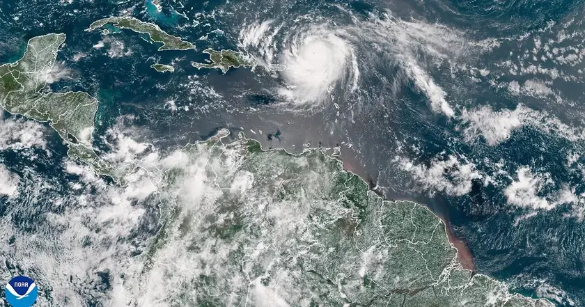
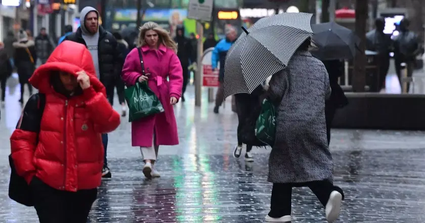
The Met Office says high pressure has returned to the UK for a largely settled week, ahead of the bank holiday. Yet the remnants of Erin could shake the forecast. Forecasters describe two main paths. If Erin is not captured by the jet stream, a new low could move in from the southwest early next week, bringing rain to the south and west. If Erin does interact with the jet stream, it could nudge the jet and set up unsettled conditions before a separate low crosses the country midweek. Either way, a period of unsettled weather is possible by late next week.
Forecasts note the track is still uncertain a week away, with confidence low for the last week of August. Deputy Chief Meteorologist Stephen Kocher cautioned that the forecast could shift as Erin’s path becomes clearer, leaving a window for wet and windy weather around the bank holiday. The forecasters also reminded readers that Erin’s journey from hurricane to post-tropical system can still influence North Atlantic weather patterns even if it does not directly hit land.
Key Takeaways
"Hurricane Erin has already brought some tragic devastation to parts of the Caribbean, Cape Verde"
Aidan notes Erin's impact before its post-tropical status
"By Sunday, it is no longer a hurricane, but still a fairly potent mid-latitude low pressure"
Description of Erin's transition from hurricane to post-tropical system
"This is still a week away however, so there is lots of uncertainty in the forecast, but it is possible we could see some wet and windy weather for the last week of August"
Forecaster highlights uncertainty and potential bank holiday impact
This forecast shows how late-summer weather depends on distant events. The jet stream, model differences, and the shift from a hurricane to a post-tropical low reveal the fragility of long-range predictions. Forecasters must balance providing timely guidance with acknowledging uncertainty, a task that grows tougher as Atlantic storms wander farther from land.
Public messaging matters here. Holiday plans, travel, and outdoor events rely on clear, cautious language about what could still change. The episode also highlights a wider theme: even as climate patterns evolve, people want reliable forecasts for planning, which puts pressure on meteorologists to communicate risk without causing unnecessary alarm.
Highlights
- Weather for late August keeps changing its mind
- Erin tests the jet stream and the calendar
- Forecasts are clear about uncertainty, not certainty
- The bank holiday outlook may hinge on a distant hurricane
Forecasts will evolve as Erin’s track becomes clearer.
Enjoyed this? Let your friends know!
Related News
Storm Erin Remnants Metered for UK

Storm Erin update reaches UK
Storm Erin Shapes UK Weather Outlook

Erin update prompt

Ukraine at stake as land swap talks surface

Mortgage approvals increase as housing market stabilizes
UK Retail Sales Increase with Hot Weather
Record number of summer journeys expected