
T4K3.news
Hidden fault systems drive slow earthquakes in Hikurangi
New research maps polygonal fault systems that influence slow-slip events off the north island coast of New Zealand.

New research maps polygonal fault systems that shape slow earthquakes in the Hikurangi subduction zone off the north island coast of New Zealand.
Hidden fault systems drive slow earthquakes in Hikurangi
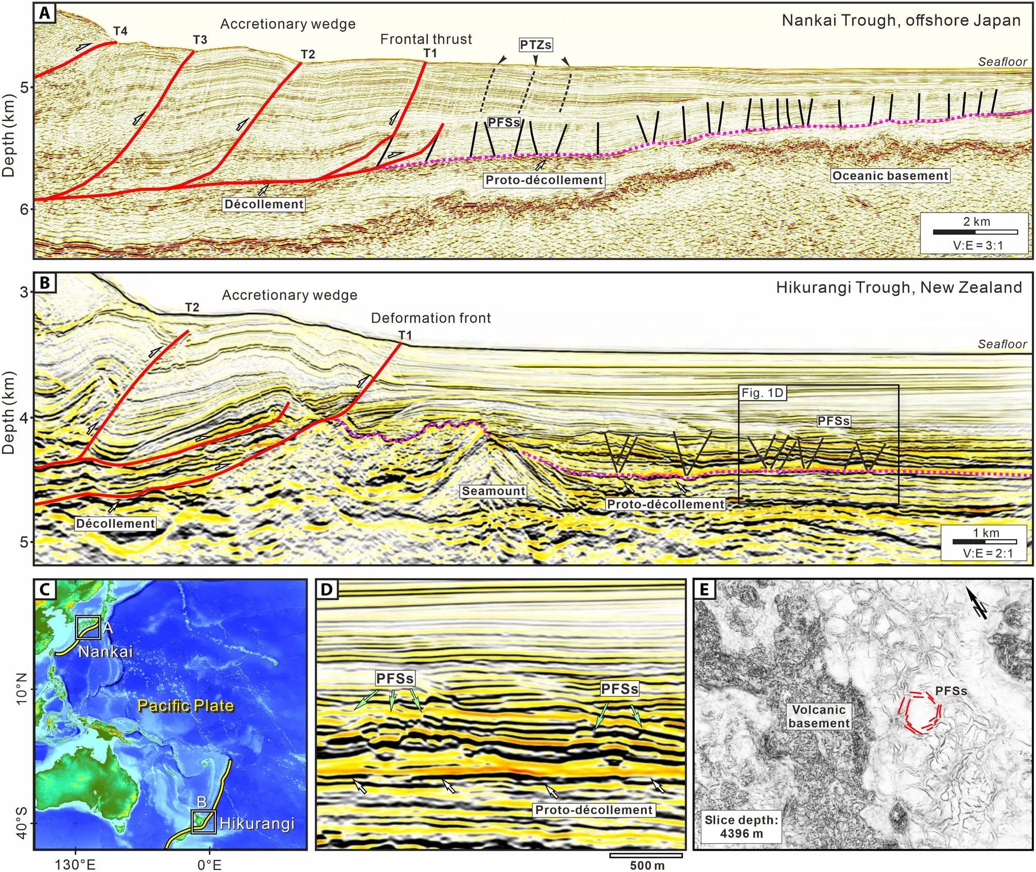
A new international study published in Science Advances identifies polygonal fault systems, shallow faults formed in sediments, as a major influence on slow slip earthquakes in the northern Hikurangi subduction zone off the north island coast of New Zealand. Using high resolution 3D seismic imaging, deep sea drilling data from the International Ocean Discovery Program, and the NZ3D seismic survey near Gisborne, researchers mapped PFSs in unprecedented detail. They say these faults form over millions of years before being dragged into the subduction zone and they can be reactivated as the sea floor moves downward, creating pathways for fluids that affect slip.
In the Hikurangi region the southern portion remains locked and can produce large earthquakes, while the northern portion regularly hosts slow slip events that unfold over days to months without violent shaking. The study shows these shallow faults influence where and how slow earthquakes occur, and it links them to stress changes on nearby faults that might trigger larger earthquakes or tsunamis. The authors say the imaging breaks a barrier in linking fault architecture to slow slip behavior and suggests similar systems may exist in other subduction zones.
Key Takeaways
"This discovery gives us a new lens to understand subduction zone dynamics."
Dr. Philip Barnes on the imaging breakthrough.
"It was not until we analyzed these 3D seismic images that we confirmed their widespread presence along the north Hikurangi margin."
Maomao Wang on the imaging breakthrough.
"Slow slip events do not cause violent shaking themselves, but they can increase stress on nearby faults."
Dr. Barnes on hazard implications.
"Similar fault systems have been observed in subduction zones around the world."
Lead author Maomao Wang on global relevance.
This study shifts how scientists think about seismic hazards. It shows that the underground structure of faults and the fluids moving through them shape slow earthquakes in ways that plate based models miss. The result is a clearer picture of a complex hydrological system driving crustal movement rather than a simple on/off switch for big quakes.
For policy and planning, the finding underscores the need for investments in high resolution imaging and long term monitoring. It also cautions against over confidence in forecasts, since slow slip events still resist easy timing. The work is globally relevant: similar polygonal fault patterns could influence slow quakes in other subduction zones, making resilience a shared challenge across coastlines.
Highlights
- Polygonal faults are the hidden highways for fluids that drive slow slips.
- We confirmed their widespread presence along the north Hikurangi margin.
- Slow slip events do not cause violent shaking, but they can raise stress on nearby faults.
- Similar fault systems exist in subduction zones around the world.
Public safety risks from slow-slip findings
Linking polygonal fault systems to slow earthquakes could affect warning systems, coastal planning, and resilience. The potential impacts touch budgets and policy readiness.
Ongoing research will test how these fault patterns shape future hazard maps.
Enjoyed this? Let your friends know!
Related News
Hidden earthquake risk discovered under North America
Warning Issued for Tintina Fault Earthquake Risk

New study reveals volcano prevention method
San Andreas quake may unfold in new patterns

AI Revolutionizes Earthquake Detection in Yellowstone

Tesla ordered to pay $240 million for Autopilot crash

8.8-magnitude earthquake prompts global tsunami warnings

Drive fault linked to Windows 11 update
